Bolt Creek Fire and Hwy 2 (closed and open and..) here are more details than you may have wanted
Tuesday, October 11, 2022
 |
| Burning stump on Hwy 2 Photo courtesy WSDOT |
By Diane Hettrick
Are you really sure you want to travel on Hwy 2?
It must qualify as the most dangerous road in the state. The stump photo is from yesterday's closure when the road was open and closed and open.
 |
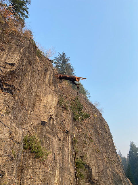
| Tree hanging over Hwy 2. It eventually fell onto the Hwy. Photo courtesy WSDOT |
 |
| Tree hanging over roadway. Photo courtesy WSDOT |
If you travel this road, it sounds like it would be a good idea for you to check the conditions when you get to Index or any place where it would be easy to turn around and find a detour.
 |
| Crew in cherrypicker remove tree from hillside. Photo courtesy WSDOT |
@WSDOT_traffic (Twitter) seems to have the most up to date information.
Here's what they posted about this tree on Tuesday:
US 2 UPDATE: Our crews will be up on US 2 today beginning at 12:30 p.m. to remove this tree. There will be a full closure of the road between MP 46-49 while they work. We will update this post throughout the day as we get reports from the field.
They finished the job and reopened at 6:44pm Tuesday.
FINAL 6:44 p.m.: US 2 has reopened. We say "Final" but this is obviously a fluid situation so more closures can happen. We'll do the best we can to get info out as quickly as we can. Please be cautious if traveling through US 2.
As far as smoke, for a while on Monday the wind blowing in off the ocean pushed the smoke from all the Cascades fires to the east.
The forecast for Tuesday isn't terrible. For up to the minute smoke forecasts, check the Smoke Map.
For those who want to know why they aren't just sending in helicopters to dump water on the fire,
they are using "consumption strategy."
Here's part of a blog entry explaining tactics.
Fire Update: Containment lines on the south, east and west edges of the fire—namely, along US 2 and near structures—continue to hold well as the consumption strategy is allowed to continue. The fire will continue to produce smoke as it burns to the north into Wild Sky Wilderness.
Firefighters remain engaged along containment lines to ensure that the fire stays in its footprint on its southern edge, as well as the southwest and southeast corners. Aviation is available and may be used – as weather allows - to make bucket drops to cool hot spots on the south and west of the fire.
Suppression activities are still ongoing to increase containment, and repair of damage caused by suppression activities will continue in some areas of the fire that have seen little fire activity in recent days.These activities include chipping vegetation, repairing hand/dozer lines and other actions that will help to mitigate future erosion. In addition to suppression repair activities, the BAER (Burned Area Emergency Response) Team will continue watershed assessments in the fire area into early next week.
Bolt Creek fire map Monday evening 10-10-22 For the first time in a month, the fire made no progress. It is still 35% contained, has burned 13,396 acres and 224 responders are assigned.
BAER team current report on their Inciweb page: https://inciweb.nwcg.gov/incident/8429/
Incident OverviewA Burned Area Emergency Response (BAER) team is working on the 2022 fires affecting the Mt. Baker-Snoqualmie National Forest (MBS): Bolt Creek, Suiattle River, Boulder Lake, and Lake Toketie.
The mission of a BAER team is a two-part assessment of post-fire watersheds. First, what are the potential risks to human life, safety, or property, and to critical natural and cultural resources? Second, what emergency stabilization measures can be implemented on federal lands in a timely manner to reduce unacceptable risks from potential flooding or debris flows?
The MBS BAER team will present their findings and recommendations to the Forest Supervisor. If the BAER team determines there may be potential emergency situations, the short-term goal is to complete flood and erosion control protection measures before the first large rain events.
Once the fire is completely out and it finally starts to rain, the next concern will be landslides from the burnt out areas on steep hillsides over roads and possibly structures.
They are saying that this fire was human-caused. No one has provided details on what evidence they have or whether it was accident or arson, but they won't be able to fully investigate until they can get in safely.
Anything else you'd like to know?


0 comments:
Post a Comment