WeatherWatcher: Tuesday Storm report, more potential snow on the way
Thursday, December 1, 2022
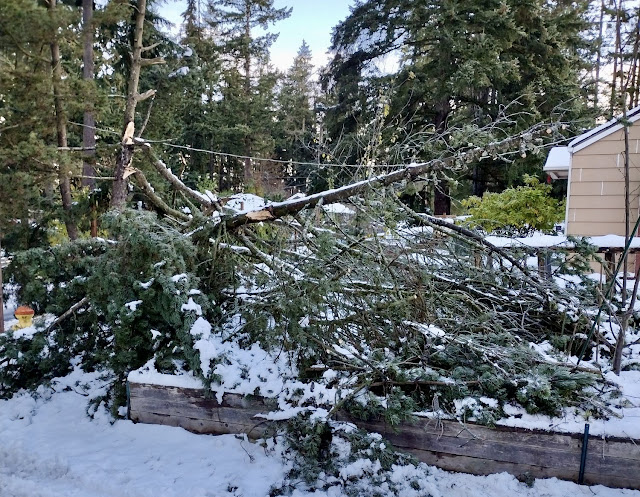
I'm going to start out by saying in my 35+ years of living memory in Shoreline, this is by far the most tree damage I've ever witnessed from any given storm. Locally, this far exceeds the major convergence zone snowstorm of December 18, 1990, or the Inauguration Day windstorm of January 1993. The 1993 storm had power out in my neighborhood for over 3 days, the 1990 storm knocked power out for almost 24 hours in my neighborhood.
This past Tuesday's storm, that same neighborhood was without power for 41 hours. Neighbors had set up a large fire pit on the street side for everyone to come warm up at, and to help dispose of some of the fallen tree matter. We have piles and piles of tree branches cleaned off the road and pushed to the sides just to get the street passable. Snow accumulations in yards were covered under a solid accumulation of tree matter.
 |
| Power lines down near the North Ridge weather station. Photo by Raymond Dinse |
As the storm was wrapping up early Wednesday morning, most of the area was without power. There was about 5 to 7 inches of heavy wet snow on trees and the ground. 45mph winds had pushed a lot of that snow into heavy snow drifts on the southeast sides of trees and any other exposed objects.
Winds combined with the unusually wet and heavy snow is what lead to the massive tree damage in the area. Temperatures particularly in the atmosphere above us were warm enough that snow was intermittently mixing with rain. Since the air near the surface was near or below freezing all that moisture in any form ended up clinging to everything and freezing once it landed.
Shoreline ended up being very much at the transition point of this storm system. Doppler radar indicated rain just south of 145th Street in Seattle and heavy snow north into Shoreline. The rainfall equivalent was nearly 1 inch of rain in this storm. Later in the evening the rain in north Seattle transitioned over to snow as the cold front pushed south.
 |
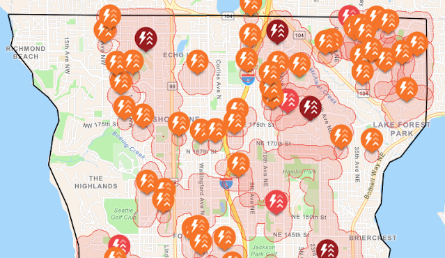
| City Light power outage map at 1:20 am November 30th |
As you can see from the outage map, most of the highland areas of Shoreline and Lake Forest Park were without power during the height of the storm. There are still a lot of broken tree limbs caught up in the tree canopy that may be coming down in future storms. Once the tree limbs settle, I think we'll see less power outages for a while as this storm has pretty much pruned out all the weak branches in our forest.
 |
| Tree and power line damage. Photo by Raymond Dinse |
Forecast: We have another storm system working its way down the Pacific coast from the northwest. Models have been all over the place on what to expect from this system. Some show a rain/snow mix, most are showing snow accumulations of 1-5 inches. There is much uncertainty in the forecasts.
Given how the other system went, I'm leaning towards the snowy version for this forecast. We could see rain and snow mixed here and there, but likely we will get some light to moderate snow accumulations out of this one as well.
Timing wise, it'll be like Tuesday, light snow, or rain/snow mixed could start up late Friday morning to early afternoon. The heavier stuff is expected Friday evening after around 4pm or so. Snow levels are expected to hover around 200-500 feet during the warmer parts of the day and could drop all the way down to sea level in the overnight hours.
There are no winter weather advisories, watches, or warning currently. In general, for the longer-range forecast, we're looking at this cool to cold pattern to continue through possibly the end of next week. A few spots here and there of rain and thawing returning to rain/snow mix or snow.


1 comments:
I can't help but wonder whether the high heat & lack of rain during the summer may have contributed to this tree-mageddon.
Post a Comment